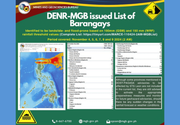
MANILA, PHILIPPINES — Environment Secretary Maria Antonia Yulo Loyzaga calls on local government units to use the DENR-MGB’s geohazard map to reduce disaster risk.
Loyzaga emphasized the importance of using the list of flood- and landslide-prone areas during pre-emptive and forced evacuation.
READ: DepEd, IT-BPM leaders discuss Philippine education
“Sana ay gamitin ito ng mga local officials natin dito sa pag-desisyon ng pre-emptive evacuation at kung saan dapat siguro maging mas ligtas ang mga kabarangay natin dito sa local government (I hope our local officials will use the map in making decisions on pre-emptive evacuation and where our people would be safer in the local government.).”
The Department of Environment and Natural Resources Secretary stated the MGB’s geohazard map receives regular updates.
The Philippine News Agency says it comes from recent Philippine Atmospheric, Geophysical, and Astronomical Services Administration (PAGASA) data.
Loyzaga stated the DENR submitted the data to the Office of Civil Defense (OCD) for LGU distribution.
“Ang ginagawa ng DENR-MGB ay base sa rainfall data ng PAGASA. Binabangga po namin ang data na yan dito sa alam namin na landslide-prone at flood-prone areas na isinagawa namin (What the DENR-MGB is doing is based on PAGASA’s rainfall data. We compare the data with areas that are known to be landslide- and flood-prone in terms of the analysis nationwide.),” she said.”
The DENR Secretary said typical landslide-prone areas are near mountainous slopes. Also, flood-prone areas are near coastal areas, rivers, and low-lying areas.
She noted that the DENR is monitoring major rivers along the upcoming typhoon Marce’s path. These include the Cagayan River Basin, the Cordillera region, and the rivers in Abra, Laoag, and Vintar in Ilocos Norte.
Loyzaga reiterated that the agency is also committed to working closely with local authorities. Moreover, it’s coordinating with concerned agencies to ensure effective information dissemination and preemptive evacuation plans.