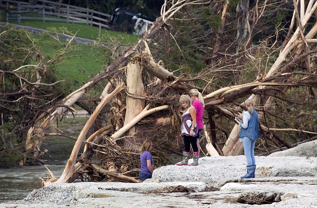
From left to right, Cara Hewitt, Linda Balas, Kathy Bullard and Doreen Crow look at the spot in Wimberley, Texas, on Thursday May 28, 2015, where eight of their friends from Corpus Christi were swept away in a flood. AP
WASHINGTON, United States — Even for a world getting used to wild weather, May seems stuck on strange.
Torrential downpours in Texas that have whiplashed the region from drought to flooding. A heat wave that has killed more than 1,800 people in India. Record 91-degree (32 Celsiu) readings in Alaska, of all places. A pair of top-of-the-scale typhoons in the Northwest Pacific. And a drought taking hold in the East.
“Mother Nature keeps throwing us crazy stuff,” Rutgers University climate scientist Jennifer Francis says. “It’s just been one thing after another.”
BACKSTORY: Floodwaters deepen in Houston after city gets more rain
Jerry Meehl, an extreme-weather expert at the National Center for Atmospheric Research, points out that May is usually a pretty extreme month, with lots of tornadoes and downpours. Even so, he says, this has been “kind of unusually intense.”
The word “stuck” provides one possible explanation.
Francis, Meehl and some other meteorologists say the jet stream is in a rut, not moving nasty weather along. The high-speed, constantly shifting river of air 30,000 feet above Earth normally guides storms around the globe, but sometimes splits and comes back together somewhere else.
A stuck jet stream, with a bit of a split, explains the extremes in Texas, India, Alaska and the U.S. East, but not the typhoons, Francis says.
Other possible factors contributing to May’s wild weather: the periodic warming of the central Pacific known as El Nino, climate change and natural variability, scientists say.
READ: Dry spell set to intensify, trigger stronger storms
For every degree Celsius the air is warmer, it can hold 7 percent more moisture. That, Texas state climatologist John Nielsen-Gammon says, “is supplying more juice to the event.”
While it is too early to connect one single event to man-made warming, scientific literature shows “that when it rains hard, it rains harder than it did 20 to 30 years ago,” says University of Georgia meteorology professor Marshall Shepherd.
FILE – In this May 29, 2015 file photo, Indians sleep on the roof of a house to beat the heat in New Delhi, India. Even for a world getting used to wild weather, May seems stuck on strange. Torrential downpours in Texas, whiplashing the region from drought to flooding. A heatwave that has already killed more than 1800 in India and is the fifth deadliest since 1900. Record 91 degree temperature in of all places Alaska. A pair of top-of-the-scale typhoons in the Northwest Pacific. And a drought in the U.S. East is starting to take root just as the one ends in Texas. (AP Photo/Tsering Topgyal, File)
As bad as the Texas flooding has been, the heat wave in India has been far worse — in fact, the world’s fifth-deadliest since 1900, with reports of the 100-degree (38 Celsiu)-plus heat even buckling roads. And it’s a consequence of the stuck jet stream, according to Francis and Weather Underground meteorology director Jeff Masters.
When climate scientists look at what caused extreme events — a complex and time-consuming process that hasn’t been done yet — heat waves are the ones most definitely connected to global warming, Shepherd says.
READ: Heat index to hit 40 Celsius in Metro on Thursday
El Nino is known to change the weather worldwide, often making things more extreme. This El Nino is itself weird. It was long predicted but came far later and weaker than expected. So experts dialed back their forecasts. Then El Nino got stronger quickly.
Some scientists have theorized that the jet stream has been changing in recent years because of shrinking Arctic sea ice, an idea that has not totally been accepted but is gaining ground, Shepherd says.
Katharine Hayhoe, a climate scientist at Texas Tech University, likens what’s happening to a stewpot: Natural climate fluctuations such as El Nino go into it. So do jet stream meanderings, random chance, May being a transition month, and local variability. Then throw in the direct and indirect effects of climate change.
“We know that the stew has an extra ingredient,” Hayhoe says, referring to climate change. “That ingredient is very strong. Sometimes you add one teaspoon of the wrong ingredient and boy, it can take your head off.”