Revamped Google maps goes offline for mobile

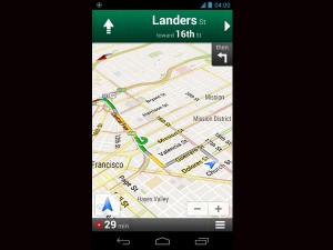
A screenshot provided by Google shows the Google Maps Navigation app for Android phones. It shows directions in San Francisco with traffic conditions in yellow and green. AP/Google
SAN FRANCISCO—Google unveiled a revamped maps program Wednesday that allows mobile users to use the service without an Internet connection as the Internet giant geared up for a possible competing service.
“You will no longer need paper maps,” said Google’s Rita Chen at an event unveiling the upgrades.
The service, which will be available soon on devices powered by Google’s Android operating system, allows users to select an area and save a local map which can be viewed when a user does not have a data connection.
This can be useful for people traveling to international locations where they do not want to pay Internet roaming charges, or for situations when someone is underground or on a plane without data access.
Chen demonstrated by saving a section of a map of London, which would still retain interactive features even without going online.
“If you have GPS enabled, the blue dot will still work,” she said.
“You can orient yourself without Wi-Fi.”
She zoomed in on the map, saying, “As we start moving in, the map remains clear, even down to street level.”
The Google upgrade comes amid widespread reports the widely used maps program will be booted off devices sold by Apple, which is developing its own mapping service.
Though Google Maps could still be downloaded and used, it would no longer be the default application for Apple users if the iPhone maker does as planned.
Google also unveiled improvements to its Street View, with access to more areas where cars cannot go, and a more detailed three-dimensional Google Earth map which allows users to view as if they were flying over a location.
Greg Sterling, an analyst at Opus Research, said Google is trying to protect its turf in maps.
“The offline mapping capability is the major announcement,” Sterling said.
“But I think they probably put this together quickly to show people that they have a comprehensive platform, and how it won’t be easily duplicated by Apple or anyone else.”
While Google does not generate much income directly from maps, it often ties into Internet search which does generate advertising dollars.
Sterling said Apple, which could announce its own maps program as the default for the iPhone as early as next week, would in theory be able to tie its mapping service to the Siri personal assistant, which could supplant Google in searching for businesses.
“If Apple does a great job (on its maps program) then we will see some substitution and may impact Google search on the iPhone,” he said.
Google also unveiled improvements to its Google Earth application, providing a more realistic three-dimensional view developed with detailed aerial images.
“We’re trying to create magic, trying to create the illusion you’re flying over the city,” Google’s Peter Birch said as he described the Google Earth view over San Francisco.
Google has long used cars to get images for its maps products, but now is deploying airplanes at well to provide richer images to help craft more detailed maps.
“We will begin adding 3D models to entire metropolitan areas to Google Earth on mobile devices, Google engineer Brian McClendon said.
“This is possible thanks to a combination of our new imagery rendering techniques and computer vision that let us automatically create 3D cityscapes, complete with buildings, terrain and even landscaping, from 45-degree aerial imagery. By the end of the year we aim to have 3D coverage for metropolitan areas with a combined population of 300 million people.”
Another improvement will be more detailed images from areas not accessible by cars. Google said it is deploying cameras on boats, specially designed tricycles and now has begun deploying people with a special backpack which has a perched camera mount.
“There are lots of gorgeous places in the world you can only walk to,” Google engineering director Luc Vincent said.
“We intend to take it to national parks, the Grand Canyon, to Venice… to places you can only dream of.”