PH Diwata’s images top US counterpart
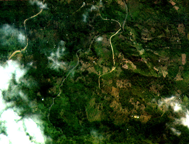
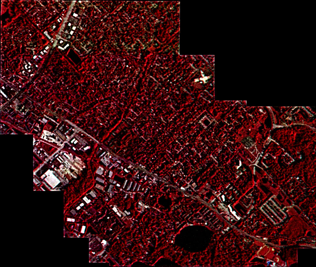
Picture taken by HPT of Diwata-1
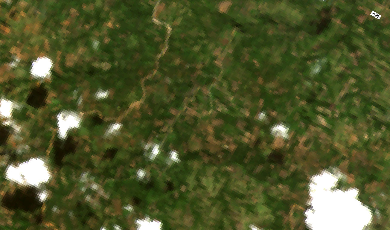
Picture taken by Landsat 8
The first Filipino-made microsatellite has outclassed an American Earth observation orbiter in terms of capturing high-resolution ground images.
The Department of Science and Technology (DOST) on Tuesday shared the first few successful photos grabbed from space by Diwata’s high-precision telescope, showing intricate details of a mountainous area in Dumingag, Zamboanga del Sur province, and an urban area in Florida, United States.
The image of the mountainous patch in Dumingag town clearly identified trees, rock surface, mountain paths, a river and some man-made objects, according to the DOST-Advanced Science and Technology Institute and the University of the Philippines Diliman.
The two institutions have been collaborating with Japan’s Hokkaido and Tohoku Universities for the operation of Diwata-1, which was launched in space in April from Florida.
Diwata-1 was deployed from the Japanese Experiment Module (JEM) on the International Space Station. The JEM Small Satellite Orbital Deployer released it at an altitude of 400 kilometers above the Earth’s surface.
Clearer images
The DOST noted that Diwata’s images were clearer than those captured by the operational land imager of its American counterpart, Landsat 8, which displayed rough structures of the mountain with unclear geographical features.
In the “false color” images of an urban area in Florida taken by Diwata, buildings and roads were distinguishable from vegetation. In contrast, the features were very unclear in the same images captured by Landsat 8, the DOST said.
“False color” images are created to emphasize the difference between vegetation and other objects using three different bands.
“In terms of resolution, ours is much better compared to [Landsat 8],” Carlos Primo David, executive director of the Philippine Council for Industry, Energy and Emerging Technology Research and Development (PCIEERD), said in a phone interview with the Inquirer on Tuesday.
DOST-PCIEERD is the monitoring agency of the microsatellite program.
Mapping out new roads
The Philippines has been using the images captured by Landsat 8, which has its own uses distinct from Diwata, for many of its research undertakings, according to David.
“The significance of these photos is that it means we can actually point Diwata anywhere in the country and image objects larger than 3 meters, such as roads. So, we can use it to map out new roads to be constructed,” he said.
Regular operations
He said Diwata would be capturing more images in the coming days as it started its regular operations this month.
Diwata’s high-precision telescope is one of the four cameras onboard the orbiter. It can capture images with a ground resolution of 3 meters at the lowest point, the highest resolution attained by a microsatellite in the 50,000-kilo class.
The ground resolution of Landsat’s operational land imager is 30 meters. The American orbiter has a launch mass of about 2,600 kilos.
“With a clearer photo from Diwata’s high-precision camera, it will be easier to see which areas are affected by natural and even man-made disasters such, as floods and fires,” the DOST said in a statement.
It noted that one of the uses of the camera was to determine the extent of damage from natural hazards like a typhoon.
Diwata’s high-precision telescope also showcased its ability to take images of places outside the country, the DOST said.
“[It is] a good indication that we can attain one of the objectives of our microsatellite development program, which is to be able to share and exchange images among a group or constellation of microsatellites with our neighboring countries for mutual benefit,” it added.
Picture taken by HPT of Diwata-1
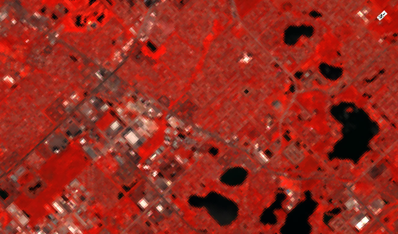
Picture taken by Landsat 8